

Javols, capitale oubliée
Throughout this circuit, you will come across pilgrimage crosses, granite fence posts, dovecote and vast panoramas of the Margeride range and the Monts d'Aubrac. Halfway, after taking the old Roman road that linked Lyon to Toulouse, you will reach Javols, former capital of the Gabales in Gallo-Roman times: a visit to the Archaeological Museum and the site is a must!
Route details
Description
From the Aumont-Aubrac town hall, go down rue de l'église to the right of the "Côté Maison" store. Pass in front of the Tourist Office and follow rue du Prieuré. Cross the D 809 and go up rue du BarriHaut. Join the D 7 and follow it for approximately 500 m.
Take the path on the left below the road (GR® 65, Chemin de Saint-Jacques-de-Compostelle).
Follow the D 7 on the left for approximately 150 m. Turn right [> dovecote] onto the local path towards La Tuile and Bouscas.
At Bouscas, take the path on the right without entering the farmyard. Join the small Cheylaret road. Follow it on the left until you reach the hamlet.
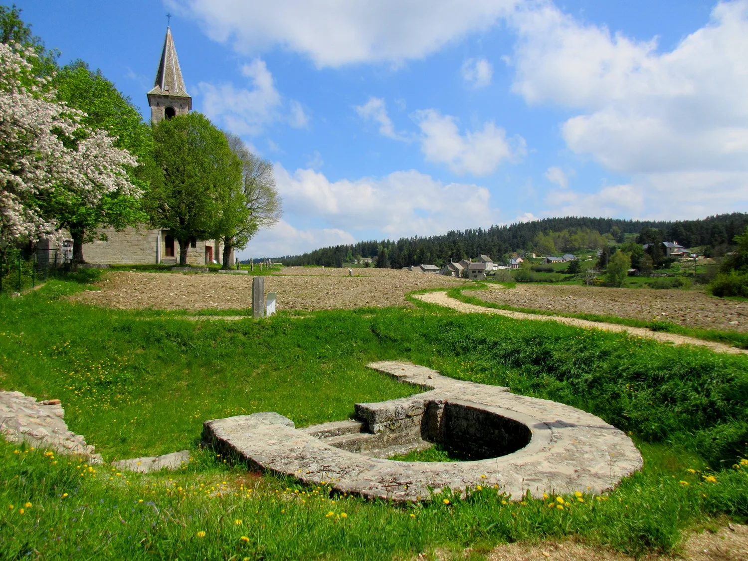
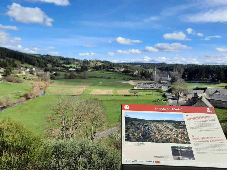
At the entrance to Cheylaret, turn right then left to go around the houses. The wide operating path follows the GR® de Pays Tour de la Margeride, [> view of the Margeride chain and the Truc de Fortunio (1552 m)]. At the junction, continue left on the old Roman Road ([ > which linked Lyon to Toulouse: approaching Javols, explanatory signs]). Go down to Javols.
In Javols, join the main street and take it on the left. Pass in front of the [ > Archaeological Museum], the church and [ > the observation platform of the Gallo-Roman site]. Pass in front of the cemetery. After the hamlet of Cros, at the crow's feet, continue left
About 200 m after the fork, leave the road (> cross a fence using a stile) and take a path on the right. It runs alongside and overlooks the Triboulin and two old mills, passes under granite blocks and above the humid plain where the stream flows.
The path continues on the slope [> alignment of granite stakes on the right]. At the edge of a wood, (> follow the signs carefully!) cross fences (> stiles!) and two footbridges over two small tributaries of the Triboulin. The path moves away from it and climbs (> cross a fence using a stile!) in the undergrowth, widening. When you reach Tiracols, turn left and follow the small road until you reach a crossroads.
Turn right onto the wide logging road which goes down. It crosses the Prévencheres stream (bridge). Ignore the trailheads on the left and right and join the GR® 65 (Chemin de Saint-Jacquesde-Compostelle, white-red markings).
Follow this wide logging road on the left until the junction with a tarmac road.
Take it to the right for a hundred meters then follow a wide path to the left [> view of the Monts d'Aubrac]. Return to point 3 then 2.
Take the path on the left below the road (GR® 65, Chemin de Saint-Jacques-de-Compostelle).
Follow the D 7 on the left for approximately 150 m. Turn right [> dovecote] onto the local path towards La Tuile and Bouscas.
At Bouscas, take the path on the right without entering the farmyard. Join the small Cheylaret road. Follow it on the left until you reach the hamlet.
At the entrance to Cheylaret, turn right then left to go around the houses. The wide operating path follows the GR® de Pays Tour de la Margeride, [> view of the Margeride chain and the Truc de Fortunio (1552 m)]. At the junction, continue left on the old Roman Road ([ > which linked Lyon to Toulouse: approaching Javols, explanatory signs]). Go down to Javols.
In Javols, join the main street and take it on the left. Pass in front of the [ > Archaeological Museum], the church and [ > the observation platform of the Gallo-Roman site]. Pass in front of the cemetery. After the hamlet of Cros, at the crow's feet, continue left
About 200 m after the fork, leave the road (> cross a fence using a stile) and take a path on the right. It runs alongside and overlooks the Triboulin and two old mills, passes under granite blocks and above the humid plain where the stream flows.
The path continues on the slope [> alignment of granite stakes on the right]. At the edge of a wood, (> follow the signs carefully!) cross fences (> stiles!) and two footbridges over two small tributaries of the Triboulin. The path moves away from it and climbs (> cross a fence using a stile!) in the undergrowth, widening. When you reach Tiracols, turn left and follow the small road until you reach a crossroads.
Turn right onto the wide logging road which goes down. It crosses the Prévencheres stream (bridge). Ignore the trailheads on the left and right and join the GR® 65 (Chemin de Saint-Jacquesde-Compostelle, white-red markings).
Follow this wide logging road on the left until the junction with a tarmac road.
Take it to the right for a hundred meters then follow a wide path to the left [> view of the Monts d'Aubrac]. Return to point 3 then 2.
